
Description of the site
The Argentona site is located at about 30 km northeast of Barcelona near the “Riera de Argentona”, an ephemeral stream. The site has a mean elevation of 3 m and an area of about 1500 m2. The climate of the area is sub-Mediterranean with a mean annual precipitation of 584 mm since 2000. Rainy seasons are spring and autumn, with generally heavy rainfall episodes in autumn. During these events, the Argentona stream may flow.
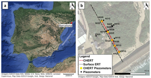
The site is located on a coastal alluvial aquifer with mostly unconsolidated sediments, which consist of two sequences located above and below a silt layer at -9 m above mean seal level. A granite basement has been found at -17 and -18 m above mean seal level with signs of intense weathering. Sixteen piezometers have been installed in a cross-shaped distribution. The axis perpendicular to the coastline is the longest with the closest piezometers to the coastline located at a distance of 40 m.
This site aims to study seawater intrusion (SWI), which contaminate drinking water resources and impact in ecological and hydrological cycles. The inland movement of saline water indeed present complex physical, chemical, mechanical and geological processes. For more information, the reader can refer to Palacios et al. (2020).
References
- A. Palacios, J. J. Ledo, N. Linde, L. Luquot, F. Bellmunt, A. Folch, A. Marcuello, P. Queralt, P. A. Pezard, L. Martínez, L. del Val, D. Bosch, and J. Carrera. Time-lapse cross-hole electrical resistivity tomography (CHERT) for monitoring seawater intrusion dynamics in a mediterranean aquifer. Hydrology and Earth System Sciences, 24(4):2121–2139, 2020. [ DOI ]
Data availability
All datasets
To help finding general datasets, predefined database requests have been created and are regularly executed. Results can be downloaded from the links available here:
Spatialized hydrogeophysics
KMZ viewer
The viewer below offers a comprehensive site visualization and information on available data such as types, numbers and dates of measurements, locations of sites, wells and stations, as well as data providers information. This interface also provides an overview of available geophysical maps and cross-sections and is accessible without a database account.
To visualize the data in the Google Earth software, you can download the following KMZ file: Argentona.kmz