Description of the site
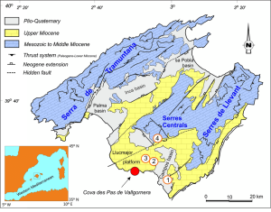
The Majorca site (12,000 m2) is located at Ses Sitjoles, in the south-east of the island. It offers an aquifer in a Miocene reefal limestone setting, highly permeable, with a number of meter-scale karstic cavities. Intensive farming and irrigation in this area have led to over-exploitation of the water, which has caused salt water intrusion up to 15 km from the coast, resulting in chloride groundwater pollution. The experimental site includes a network of twelve boreholes of 100 m depth, with six fully cored. The site is monitored by a team from UMR Géosciences Montpellier for:
- In situ characterization using borehole-measurement campaigns: geological structure intersected (walls imagery); petrophysical characterization (electrical, acoustic, natural radioactivity); and flows characterization using hydro-geophysical methods (discharge, self-potential, hydro-dispersive behaviour, etc.).
- Petrophysical and x-ray tomographic characterization of cores
- Continuous reservoir monitoring using new geophysical observation techniques (igeo-SER) for periodic measurements (hourly or daily) of variables such as electrical resistivity and electrokinetic potential, pressure and temperature, and ionic load of fluids.
- Regular sampling and analysis of fluids.
- Data analysis to evaluate the reservoir’s response to external stresses both natural (climatic, tectonic, etc.) and induced, for instance during experimentation (tracer injection, pumping).
- Simulation and modelling of transport processes within the reservoir.
The team is also working on a experimental site Lavalette near from Montpellier.

Data availability
Predefined requests
To help finding general datasets, predefined database requests have been created and are regularly executed. Results of the requests can be downloaded from the links available here:
Water cycle
Geochemical cycle
Borehole hydrogeophysics
- Acoustic and optical logs
- Caliper logs
- Multiparameters logs
- Focussed electrical resistivity
- Normal electrical resistivity
- Induction resistivity
- Natural and spectral radioactivity gamma
Boreholes
KMZ viewer
The viewer below offers a comprehensive site visualization and information on available data such as types, numbers and dates of measurements, locations of sites, wells and stations, as well as data providers information. This interface also provides an overview of available geophysical maps and cross-sections and is accessible without a database account.
To visualize the data in the Google Earth software, you can download the following KMZ file : Mallorca.kmz
