

Scientific context
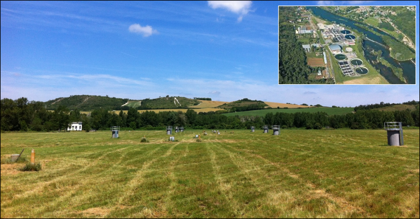
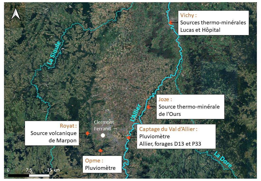
The AUVERWATCH observatory (AUVERgne WATer CHemistry) aims to characterize water bodies in Auvergne (volcanic, sandy, alluvial, crystalline, thermo-mineral aquifers, and precipitation) and ensure their long-term monitoring in order to observe the evolution of these hydrosystems in the face of anthropogenic pressures and climate change. AUVERWATCH focuses in particular on the Allier alluvial aquifer, one of the main tributaries of the Loire, 410 km long and covering a watershed of more than 14,000 km². Observations are mainly concentrated at the Val d’Allier site, an unconfined alluvial aquifer near Clermont-Ferrand, exploited by Clermont Auvergne Métropole to produce 80% of its drinking water supply. The aquifer’s water volume is estimated at 2 billion m³, and the alluvial plain hosting it is mainly occupied by livestock and agriculture (71%), followed by forests and grasslands (24%), with little urbanization (5%). The Quaternary alluvial deposits consist mainly of gravel and sandy sediments poor in clay, overlying marly limestone deposits (Oligocene) of the Limagne or directly resting on the crystalline basement.
AUVERWATCH includes a second site, Port-Douvot, located near Besançon in Bourgogne–Franche-Comté. This experimental site, on the Doubs alluvial aquifer, consists of an aquifer with an average thickness of 10 m made up of pebbles, gravels, and coarse sands resting on a marly substratum. It is also part of the SNO RENOIR, providing monthly isotopic precipitation data.
The goal of the studies conducted at these two sites is to better constrain the pressures exerted on alluvial aquifers and to improve the understanding of groundwater/river interactions, with a focus on the reactivity of alluvial deposits. AUVERWATCH is jointly managed by the Université Marie et Louis Pasteur (UMLP) and the Observatoire de Physique du Globe de Clermont-Ferrand (OPGC).
Localization: Val d’Allier: 45°73′ N, 3°22′ E, Auvergne-Rhône-Alpes, France
Port-Douvot: 47°20′ N, 5°98′ E, Bourgogne-Franche-Comté, France
Start: 2014 (Val d’Allier), 2019 (Port-Douvot).
Website: https://opgc.uca.fr/autres-services-dobservation/auverwatch
Database: https://wwwobs.univ-bpclermont.fr/data-center/public/data/auverwatch
Supervisors: Hélène Celle (UMLP, Laboratoire Chrono-Environnement) et Gilles Mailhot (UCA, ICCF)
Keywords: alluvial aquifer, groundwater/river interactions, water resources, fiber optics, global changes, modeling, long-term monitoring.
Scientific goals
AUVERWATCH is structured around three main objectives:
- Characterize the evolution of water resources, in terms of both quantity and quality, in the context of global climate and socio-economic change.
- Assess the functioning and reactivity of alluvial hydrosystems, which are crucial for regional water use (70% across all sectors), particularly with regard to contamination.
- Align scientific studies with the needs of regional stakeholders, notably through the development of water-management tools aimed at improving the sustainable management of water resources.
Instrumentation and measurements
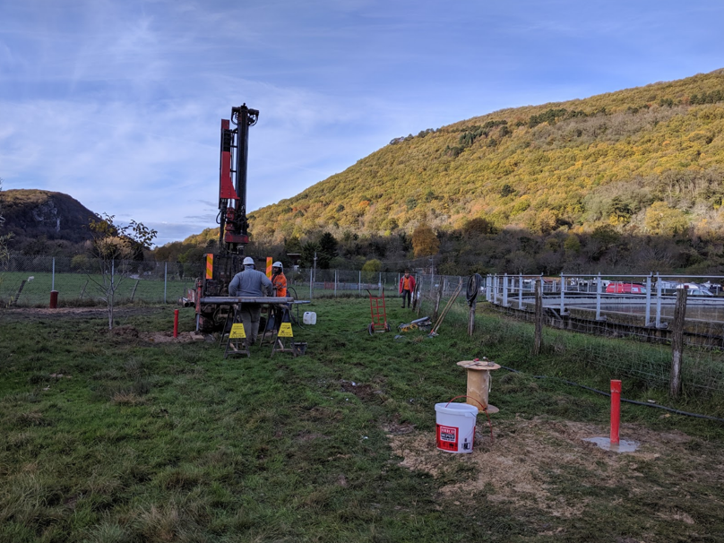
AUVERWATCH currently includes nine measurement stations located on the Limagne plain, comprising boreholes in the alluvial aquifer (the Clermont-Ferrand wellfield, known as the “Val d’Allier”), measurement points in the river and in various volcanic (Marpon) and thermomineral springs (Ours and Vichy), as well as rain collectors. These stations are monitored from a hydrodynamic perspective (CTD sensors measure hourly variations in water level, temperature, and electrical conductivity) and from a physico-chemical perspective through monthly sampling for the analysis of 100 to 500 parameters (major-ion chemistry, organic chemistry, stable isotopes of water molecules, and microbiology), depending on the site. The instrumented sites also allow the development of transdisciplinary experiments on the alluvial aquifer, combining hydrogeology, hydrochemistry, geophysics, and distributed temperature sensing using fiber optics (Raman, Brillouin).
The Val d’Allier consists of 71 pumping wells associated with observation piezometers that have enabled the monitoring of the alluvial aquifer level since 2017, while the Port-Douvot experimental site includes one pumping well and eight piezometers. Several fiber-optic lines have also been installed vertically within the alluvium to measure groundwater fluxes (Raman & Brillouin), under both natural and forced conditions.
The objective of the studies carried out at these two sites is to better constrain the pressures exerted on alluvial aquifers and to improve the understanding of groundwater–river interactions, with a focus on the reactivity of alluvial deposits.
Partners
AUVERWATCH is jointly managed by scientific stakeholders and water-resource managers, and includes the following academic and socio-economic partners:: the laboratoire Chrono-Environnement de l’Université Marie et Louis Pasteur (UMLP), the Observatoire de Physique du Globe de Clermont-Ferrand (OPGC), the Institut de Chimie de Clermont-Ferrand, the laboratoire Sciences pour l’Environnement de l’université de Corse, the UFR de Biologie de l’université Clermont Auvergne, Clermont Auvergne Métropole, l’Agence de l’eau Loire-Bretagne, et the Vichy laboratories.
Projects and publications
Projects are available here, and publications here.
Data access
OPGC database
Hydrogeochemistry data of the different measurement points of the Val d’Allier sites are available in the OPGC database.
KMZ viewer
The viewer below offers a comprehensive site visualization and information on available public data such as types, numbers and dates of measurements, locations of sites, wells and stations, as well as data providers information. This interface also provides an overview of available geophysical maps and cross-sections.
To visualize all data in the Google Earth software, you can download the following KMZ files: Port-Douvot.kmz & Val-d-Allier.kmz
Port-Douvot
Val d’Allier
Predefined requests
Geophysical profiles, weather station datasets, piezometric levels and multiparameter probe measurements at Port-Douvot and Val d’Allier sites are available in the H+ database. To help finding general datasets, predefined database requests have been created and are regularly executed. Results of the requests can be downloaded from the links available below.